- Home
- Kushimoto Sightseeing guide map
Kushimoto Sightseeing guide map
This guide map shows attractive sightseeing spots in Kushimoto in detail and Nanki area from Shirahama, Nachi Katsuura to Kumano.
Kushimoto Area
-
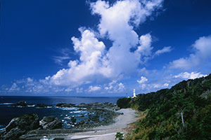
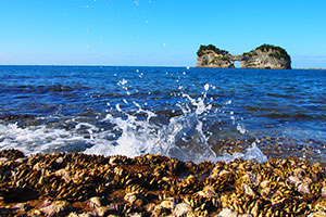
- Shionomisaki Cape
- Shionomisaki cape in Kushimoto-cho is the southernmost cape of the main island where the black current crashes to the cliff. It is famous for rock- and boat-fishing. In the winter season, magnificent scenes of a sunrise in the east horizon and sunset in the west are also popular.
-
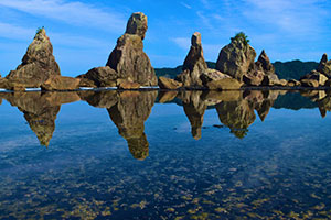
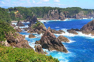
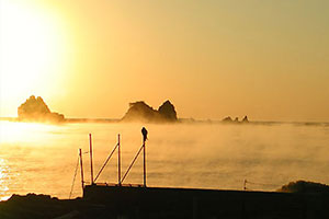
- Hashikuiiwa Rocks
- They are a line of rock pillars in a row of about 850m (930 yard) toward Oshima Island. The weird-looking rocks look like as if only bridge pillars were standing. This is one of he best scenic spots in Nanki area.
-

- Kushimoto Underwater Park
- The park was designated in 1970 as one of the first underwater parks in Japan. The annual average water temperature is 16 to 30℃ (60.8 to 86 ℉). There is a 24-meter under tunnel in the aquarium, where you can see powerful scenery of sandbar sharks and spotted eagle rays swimming leisurely above your head.
-
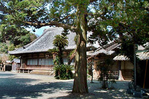
- Muryouji Temple
- This temple is one of the largest temples in Kishu area, which was opened by Kokan Zen patriarch of the Linji Tofukuji school. It is also called the “Rosetuji temple in Kinan.” In the pricenct of the temple, there is a famous Okyo Rosetsu Museum where there are many paintings painted on Japanese sliding doors by Maruyama Okyo and his disciple Nagasawa Rosetsu.
-
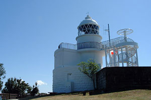
- Kashinozaki
- At the east end of Oshima Island, there is Japan’s oldest stone-made lighthouse that is still active now. The lighthouse was designed by a British engineer. There are narcissus flowers growing in clusters there, which are believed to have been planted by the engineer when he was staying there. Many pretty flowers are in full bloom, giving a sweet scent around in winter.
-
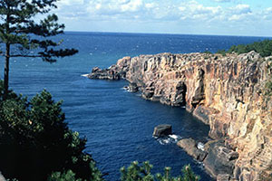
- Umikongo
- Umikongo is named after the popular Mr. Kongo in the Korean Peninsula. Rough waves crash the steep reef, giving a spectacular scene. Various sizes of rocks and the cliffs grinded by rough waves are commended as the ultimate models created by nature. It was chosen as the location of a movie “125 Years Memory.” It is also listed as one of the “100 Best Natures in Japan to keep in the 21st Century.”
Kumano and Nachi Katsuura Areas
-
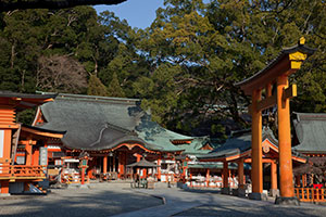
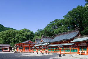
- Kumano Nachi Taisha Shrine
- Kumano Nachi Taisha Shrine is located in Nachi Katsuura-cho, Higashi Muro District, Wakayama prefecture. The shrine is one of the Kumanosanzan shrines, whose main enshrined deity is Kumano Fusuminokami. It used to be called Nachi Shrine, Kumano Fusumi Shrine or Kumano Nachi Shrine. It is also called Kumano Junisho Gongen, Jusanjo Gongen or Nachisan Gongen. It is selected as a UNESCO world heritage site.
-
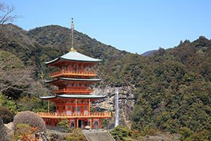
- Nachi Falls
- Nachi Falls is well known as the biggest fall in Japan. The fall is the sacred object of Hirojinja, which is an associated shrine of Kumano Nachi Taisha Shrine, whose enshrined deity is Oanamuchi no kami. It is believed that when Emperor Jimmu (711-585 BC) went on an eastern expedition, he landed this place and worshipped Oanamuchi no kami and proceeded over the mountains to Yamato, accompanied by a mythical raven. After that, the shrine building was moved from Nachi Falls to the present Nachi Taisha Shrine in the period of Emperor Nintoku (257-399AD). Since then, the shrine is called Hirojinja, which is an associated shrined of Kumano Nachi Taisha Shrine.
-
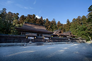
- Kumano Hongu Taisha Shrine
- Kumano Hongu Taisha Shrine: Chief god is Ketsumikono kami
This shrine is the center of Kumano Sanjagongen shrines and is Amithaba, which is the syncretism of Buddha and Shinto.
It survived the 1889 flood, and was moved from Oyumohara to the present location, standing in a unique atmosphere among the cedar trees. It is said that pilgrims to Kumano used to manage to reach here after a daunting journey.
-
- Kumano Hayatama Taisha Shrine
- Kumano Hayatama Taisha Shrine: Chief god is Hayatamano kami
The shrine is one of the Kumano sanjagongen whose main enshrined deity is Yakushi Nyorai that is the syncretism of Buddha and Shinto.
Pilgrims to Kumano Hongu Taisha Shrine went down Kumano river to visit Kumano Hayatama Taisha Shrine and Kumano Nachi Taisha Shrine. They crossed Okumotorigoe ridge back to Kumano Hongu Taisha again, and then went back home.
-
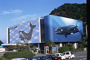
- Whale Museum
- Taichi Whale Museum, the largest whale museum in the world, showcases ecological items of whales and 1000 important exhibits for whale fishing. You can learn the 400 years of history in this birthplace of Japan’s whale fishing with great interest.
-
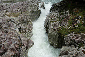
- Takinohai Fall
- Takinohai is a mountain stream waterfall with a fall of 8m high (26 feet) and located in the tributary of Kozagawa river. There are numberless various sized holes made by “Takinohai” erosion. The fall in the center drops vigorous water, sound of which blends into nature.
-
- Monolith Rock
- The monolith rock is a national natural monument, showing a magnificent scenery.
-
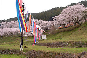
- Shichikawa Dam
- The Shichikawa dam is famous for cherry blossom. The boulevard of cherry trees on the road along the reservoir is listed as the Top 100 Cherry Blossom Sites in Japan.
-
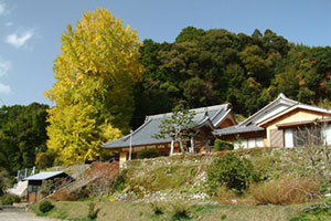
- Kosenji Temple
- The large ginkgo tree in Kosenji Temple is estimated 400 years old. It is 30m (100 feet) high and the trunk is 6m (20 feet) thick. It offers a breath of fresh green in spring, provides a shade blocking ultraviolet rays in summer, and covers the land with a yellow carpet of gingko leaves in autumn.
-
- Arafune Coast
- An intricate coast from Tawara to Shimosato is called the Arafune coast. The well-known place of the beautiful coastline offers rich see food such as turban shells, abalones and Ise lobsters.
Shirahama Beach Area
-
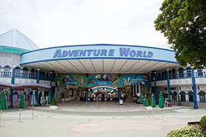
- Adventure World
- Adventure World is well-known as breeding the “highest number of giant pandas” in Japan. You can enjoy not only watching pandas, but also eating panda gourmet food and shopping panda puppies and goods. This place is the best place for panda lovers. There are also many other animals here.
-
- Engetsu Island
- Engetsu Island is familiar as the symbol of Shirahama beach, whose official name is Takashima. It is a small island in the Pacific Ocean off the Rinkaiura beach, size of which is 130m (142 yard) north-south, 35m (38 yard) east-west and 25m (27 yard) high. It is called the Engetsu (full moon) island because there is a sea cave in the center of the island. The sunset over the island is selected as one of the “Top 100 Sunsets in Japan” and the sunset is exceptionally beautiful.
-
- Sandanbeki Rock Cliff
- The rock cliff is 50 to 60m (55 – 66 yard) high and standing on the south coast of the Senjojiki Rock Plateau. The large rock cliff is named after the “Midan” (watching deck) and extends 2 km (1.2 miles) north-south. You can enjoy the dynamic nature of the black current rushing to the cliff. You cannot help but be impressed by the power of nature. It was selected in April 2016 as lovers’ sacred place “Nanki Shirahama Sandanbeki.” There are 140 lovers’ sacred places in Japan. In Wakayama prefecture, this is the second sacred place after Wakayama Marina City.
-
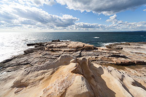
- Senjojiki Rock Plateau
- As its name suggests, the Senjojiki Rock Plateau is like a large carpet made of rock. The slope-like whitish soft rock extruding into the Pacific Ocean from the Setozaki Cape is sandstone of the Tertiary deposit. It has been eroded by raging waves, exhibiting a magnificent scenery.
-
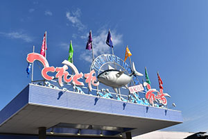
- Toretore Market
- Toretore Market is one of the largest seafood markets in the western Japan. As it is run by the local Katata Fisherman’s Union, tastes and freshness are guaranteed and the price is reasonable. A variety of nationwide seafood and Wakayama’s specialties are being sold. You can fully enjoy seafood-topped rice bowls and fresh seafood in the Toretore Street.
-
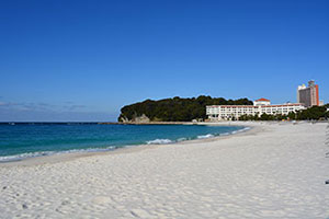
- Shirarahama Beach
- The 620m (678 yards) long shallow beach is filled with quartz sand including 90% of silica - whitish smooth sand as its name suggests. In the summer, many colorful beach parasols are opened. The palm-trees standing along the curved beach also create a tropical atmosphere.